- Home
- Telecom
- Telecom Features
- NavIC Navigation With Indian Constellation: What Exactly Is It? How Does It Work?
NavIC - Navigation With Indian Constellation: What Exactly Is It? How Does It Work?
NavIC recently made headlines when Realme X50 Pro 5G was confirmed to feature support.

Realme CEO Madhav Sheth said the company’s latest flagship comes with NavIC support.
Realme on Thursday revealed that its Realme X50 Pro 5G smartphone comes with support for the Indian Space Research Organisation's (ISRO's) Navigation With Indian Constellation (NavIC) technology, making it the first smartphone to support India's indigenous navigation satellite system. Developed by the country's premier space agency, the Indian Space Research Organisation (ISRO), NavIC provides accurate location positioning to users in India and neighbouring regions. It has increasingly found itself to be a part of conversations in the recent weeks and if you are a little behind on your NavIC knowledge, here's a quick explainer.
What is NavIC?
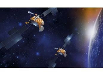
NavIC is also known as the Indian Regional Navigation Satellite System (IRNSS) and aims to provide the most accurate and precise location service to the users of the technology. It is powered by eight IRNSS satellites, of which one provides messaging services. ISRO explains, "Three satellites are located in suitable orbital slots in the geostationary orbit and the remaining four are located in geosynchronous orbits with the required inclination and equatorial crossings in two different planes. All the satellites of the constellation are configured identically. The satellites are configured with I-1K Bus to be compatible for launch on-board PSLV."
It is an independent regional navigation satellite system developed by ISRO, and is designed to provide accurate position information service to users in India as well as the region extending up to 1,500 km from India's boundary, which is its primary service area.
NavIC will provide two types of services – Standard Positioning Service (SPS) which is provided to all the users and Restricted Service (RS), which is an encrypted service provided only to the authorised users.
How will NavIC reach smartphone users?
Now, NavIC is a smartphone feature and will reach to end users as a geo-mapping feature within their smartphone chips.
American chipmaker Qualcomm had, in October 2019 announced that it will add NavIC support to its chipsets. In January, the company announced that three of its Snapdragon chipsets – the Snapdragon 720G, Snapdragon 662, and the Snapdragon 460 will support NavIC.
However, these aren't the only Qualcomm chipsets to support NavIC technology. In a statement to Gadgets 360, the company revealed, "Recent Snapdragon Mobile Platform launches such as Snapdragon 765, 720G, 662 and 460 support NavIC. Snapdragon 865 is NaviC capable with the final software update coming to our OEMs around April 2020." The mention of the last chipset, the Snapdragon 865, helps understand how the Realme X50 Pro 5G - which runs on the SoC - has support for the NavIC navigation system.
How will NavIC benefit smartphone users
NavIC enhancements will improve user experience for location-based applications, and will enhance location tracking in dense urban environments where geolocation accuracy tends to degrade. In other words, where the US-built Global Positioning Systme (GPS) lacks in navigating through densely built areas, with the help of NavIC, it will be easier to locate your way around dense areas.
It enables more accurate location performance, and faster time-to-first-fix (TTFF) position acquisition, and improved quality of location-based services.
Some more applications of NavIC are:
- Aerial and marine navigation
- Disaster Management
- Tracking vehicles and fleet management for businesses
- Improved Timing
- Improved Mapping and Geodetic data capture
- Terrestrial navigation aid for hikers and travellers
- Visual and voice navigation for drivers
Essentially, NavIC will improve everything that GPS lacks in terms of navigating in Indian environment, since it will enable Indian satellites to track location and for mapping purpose. NavIC has a position accuracy better than 20 metres in the primary service area.
Catch the latest from the Consumer Electronics Show on Gadgets 360, at our CES 2026 hub.
Related Stories
- Samsung Galaxy Unpacked 2025
- ChatGPT
- Redmi Note 14 Pro+
- iPhone 16
- Apple Vision Pro
- Oneplus 12
- OnePlus Nord CE 3 Lite 5G
- iPhone 13
- Xiaomi 14 Pro
- Oppo Find N3
- Tecno Spark Go (2023)
- Realme V30
- Best Phones Under 25000
- Samsung Galaxy S24 Series
- Cryptocurrency
- iQoo 12
- Samsung Galaxy S24 Ultra
- Giottus
- Samsung Galaxy Z Flip 5
- Apple 'Scary Fast'
- Housefull 5
- GoPro Hero 12 Black Review
- Invincible Season 2
- JioGlass
- HD Ready TV
- Laptop Under 50000
- Smartwatch Under 10000
- Latest Mobile Phones
- Compare Phones
- Motorola Signature
- Vivo Y50e 5G
- Vivo Y50s 5G
- Realme 16 Pro+ 5G
- Realme 16 Pro 5G
- TCL Nxtpaper 70 Pro
- OPPO A6 Pro 5G
- Honor Power 2
- Lenovo Yoga Slim 7x (2025)
- Lenovo Yoga Slim 7a
- Realme Pad 3
- OPPO Pad Air 5
- Xiaomi Watch 5
- Huawei Watch 10th Anniversary Edition
- Acerpure Nitro Z Series 100-inch QLED TV
- Samsung 43 Inch LED Ultra HD (4K) Smart TV (UA43UE81AFULXL)
- Asus ROG Ally
- Nintendo Switch Lite
- Haier 1.6 Ton 5 Star Inverter Split AC (HSU19G-MZAID5BN-INV)
- Haier 1.6 Ton 5 Star Inverter Split AC (HSU19G-MZAIM5BN-INV)


