- Home
- Internet
- Internet News
- You Can Now Embed Street View and Photo Sphere Images From Google Maps
You Can Now Embed Street View and Photo Sphere Images From Google Maps

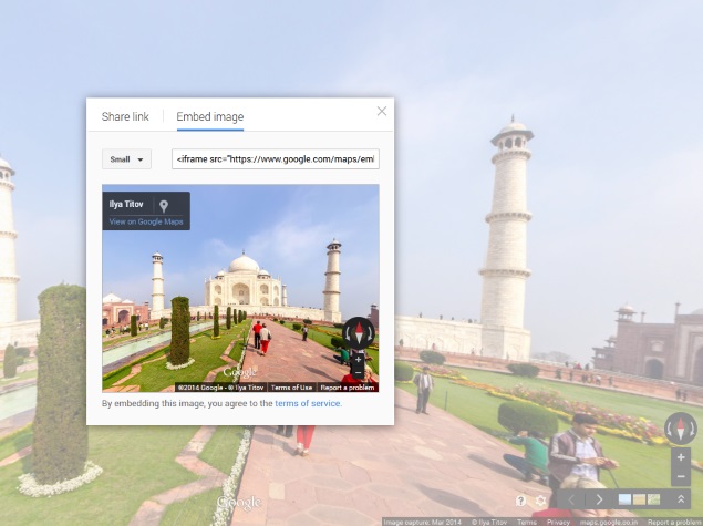
The company says that these embeds are fully functional and use the new imagery viewer technology that powers Street View in the new Google Maps.
To embed a Street View image or a Photo Sphere, any user can simply click on the 'gear icon' in the bottom right corner of the image interface on Google Maps and can then choose the 'Share and embed image' option to get the HTML embed code for their website or blog, or for any place where HTML-based embed codes are supported.
The embedded Street View and Photo Sphere images can also be of custom size, and users can also choose from small, medium, and large-sized presets. Of course, the Street View and Photo Sphere images the user wants to embed need to be publicly available.
Apart from embedding Street View images or Photo Spheres found via Google Maps, users can also visit Google Maps' Views community, where other users have publicly shared Street View and Photo Sphere imagery. To embed an image from there, users will need to click through to the image of choice, then click on the share icon on the right - the 'Embed this image' option will pop up.
"Embedding a Street View or Photo Sphere works similarly to the Street View Service in Google Maps JavaScript API v3 - specify a lat/ lng or panorama ID to pick your location, plus heading and pitch to determine direction of the scene and angle of the camera," noted Ken Hoetmer, Product Manager, Google Maps APIs.
In March, the company had released Google Maps Embed API that "enables developers to generate HTML snippets that embed Google Maps within their own website", but it did not include Street View and Photo Sphere images.Earlier this week, Google had announced the updated Google Play services 6.5 for Android developers that include several new features for Google Maps, Google Drive, Google Wallet, and Google Fit APIs.
The biggest new addition in Google Maps Android API is the maps toolbar that lets users get directions and turn by turn navigation without leaving the third-party app. The Google Play services 6.5 also brings the new 'lite mode' map option in Google Maps API.
"A lite mode map is a bitmap image of a map at a specified location and zoom level," explains Google's Android Developer blog.For the latest tech news and reviews, follow Gadgets 360 on X, Facebook, WhatsApp, Threads and Google News. For the latest videos on gadgets and tech, subscribe to our YouTube channel. If you want to know everything about top influencers, follow our in-house Who'sThat360 on Instagram and YouTube.
Related Stories
- Samsung Galaxy Unpacked 2025
- ChatGPT
- Redmi Note 14 Pro+
- iPhone 16
- Apple Vision Pro
- Oneplus 12
- OnePlus Nord CE 3 Lite 5G
- iPhone 13
- Xiaomi 14 Pro
- Oppo Find N3
- Tecno Spark Go (2023)
- Realme V30
- Best Phones Under 25000
- Samsung Galaxy S24 Series
- Cryptocurrency
- iQoo 12
- Samsung Galaxy S24 Ultra
- Giottus
- Samsung Galaxy Z Flip 5
- Apple 'Scary Fast'
- Housefull 5
- GoPro Hero 12 Black Review
- Invincible Season 2
- JioGlass
- HD Ready TV
- Laptop Under 50000
- Smartwatch Under 10000
- Latest Mobile Phones
- Compare Phones
- Moto G15 Power
- Moto G15
- Realme 14x 5G
- Poco M7 Pro 5G
- Poco C75 5G
- Vivo Y300 (China)
- HMD Arc
- Lava Blaze Duo 5G
- Asus Zenbook S 14
- MacBook Pro 16-inch (M4 Max, 2024)
- Honor Pad V9
- Tecno Megapad 11
- Redmi Watch 5
- Huawei Watch Ultimate Design
- Sony 65 Inches Ultra HD (4K) LED Smart TV (KD-65X74L)
- TCL 55 Inches Ultra HD (4K) LED Smart TV (55C61B)
- Sony PlayStation 5 Pro
- Sony PlayStation 5 Slim Digital Edition
- Blue Star 1.5 Ton 3 Star Inverter Split AC (IC318DNUHC)
- Blue Star 1.5 Ton 3 Star Inverter Split AC (IA318VKU)


