- Home
- Internet
- Internet News
- Nokia's Here LivingCities maps visualises traffic in Mumbai and other cities
Nokia's Here LivingCities maps visualises traffic in Mumbai and other cities
By Anupam Saxena | Updated: 3 July 2013 17:00 IST

Click Here to Add Gadgets360 As A Trusted Source

Advertisement
Nokia's Here location services unit in collaboration with CartoDB, a cloud based mapping, analysis and visualization engine, has released a web project called Living Cities that visualises traffic in a time-lapsed format over the course of 24 hours, in five different global cities, namely, Mumbai, London, Chicago, Rome and Helsinki.
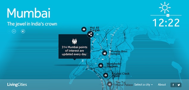
GigaOM reports that the project anonymised data collected by the Here platform and shared it with CartoDB which then visualised traffic movement over a period of one month. In Mumbai, it covered 18 million people, 1.8 million vehicles and 1900 km of roads.
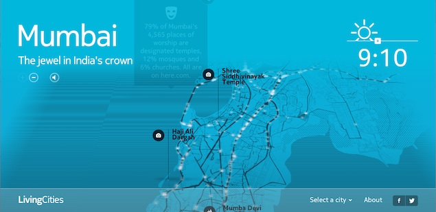 The LivingCities map offers two zoom levels giving a close view of major roads and intersections, and points of interest, with the flow of traffic being visualised through moving white light. The map also offers sounds experienced on the roads of the city and statistics and trivia related to the city, its points of interest and traffic patterns that can be shared on Facebook and Twitter. The map features a slider for time to toggle view across 24 hours. The colours of the map turn bright and dark inline with the time depicting the outside conditions.
According to Nokia, the data behind this visualisation is continuously collected by Here through connected devices such as Nokia mobile phones, the Here web apps and in-car navigators powered by Here. It clarifies that no personal data is collected and that it collects small data changes to find out how the traffic is flowing in the city, whether a road is closed, or a new road has opened, among others.
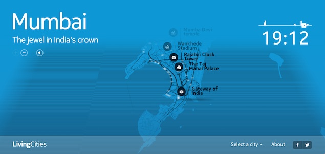 The traffic map of Mumbai shows how traffic is consistently heavy during a large part of the day though the average speed increases after 8:30pm and peaks at late hours, which is in contrast to traffic in Helsinki where traffic reduces considerably after evening.
 The map is essentially an attempt to encourage developers to take a look at data APIs offered by Here maps to develop their own city visualisations, according to Nokia. If deployed at a large scale, the map could help governments and enterprises in planning the city better and placing establishments depending on the flow of traffic.
GigaOM reports that the project anonymised data collected by the Here platform and shared it with CartoDB which then visualised traffic movement over a period of one month. In Mumbai, it covered 18 million people, 1.8 million vehicles and 1900 km of roads.
According to Nokia, the data behind this visualisation is continuously collected by Here through connected devices such as Nokia mobile phones, the Here web apps and in-car navigators powered by Here. It clarifies that no personal data is collected and that it collects small data changes to find out how the traffic is flowing in the city, whether a road is closed, or a new road has opened, among others.
Comments
Get your daily dose of tech news, reviews, and insights, in under 80 characters on Gadgets 360 Turbo. Connect with fellow tech lovers on our Forum. Follow us on X, Facebook, WhatsApp, Threads and Google News for instant updates. Catch all the action on our YouTube channel.
Advertisement
Follow Us
-

03:58
Dreame D20 Ultra Review: The Most Intelligent Robot Vacuum Cleaner Under ₹40,000? -
03:23
iPhone Fold Leaks & Rumors 2026 | Apple's Foldable iPhone Launch, Price & Specs Revealed -
04:12
Samsung Galaxy A37 Review: Camera, Gaming & Battery Tested! -
14:16
[Partner Content] OPPO F33 Pro 5G Explained: Built for the Big Moments -
05:21
Poco X8 Pro Max Review | Is This the Ultimate Budget Beast?
-
50MP कैमरा, 8000mAh बैटरी के साथ Realme 16T 5G लॉन्च, जानें सबकुछ
-
Motorola का फ्लिप फोन हुआ 43 हजार से भी ज्यादा सस्ता, जबरदस्त गिरी कीमत
-
Realme Watch S5 लॉन्च, 20 दिन चलेगी बैटरी, जानें क्या हैं खासियतें
-
Motorola Edge 70 Pro+ जल्द होगा भारत में लॉन्च, 50 मेगापिक्सल का प्राइमरी कैमरा
-
अब ChatGPT बना देगा पूरा PowerPoint प्रेजेंटेशन, OpenAI ने लॉन्च किया नया फीचर
Advertisement
Popular on Gadgets
- Samsung Galaxy S26 Ultra
- Motorola Razr Fold
- ChatGPT
- OPPO Find N6
- Mobiles Under Rs. 40,000
- Vivo X300 Ultra
- Asus Zenbook S14
- iQOO 15
- Vivo X300 Pro
- Lenovo Yoga Slim 7i Aura Edition
- iQOO 15R
- Vivo X Fold 5
- Sony PlayStation 5
- HP OmniPad 12
- OnePlus Nord CE 6 Lite
- OnePlus Pad 4
- OPPO F33 Pro 5G
- Cryptocurrency
- HP OmniBook Ultra 14 (2026)
- iPhone 17
- Eureka Forbes AP 355 Room Air Purifier
- Latest Mobile Phones
- Compare Phones
Latest Gadgets
- Realme 16T 5G
- Xiaomi 17 Max
- HMD Vibe 2 5G
- iQOO 15T
- Lenovo Legion Y70 (2026)
- Red Magic 11S Pro+
- Red Magic 11S Pro
- Vivo Y60
- Microsoft Surface for Business (2026, 15-Inch)
- Microsoft Surface for Business (2026, 13.8-Inch)
- Poco Pad C1
- iQOO Pad 6 Pro
- Realme Watch S5
- Xiaomi Smart Band 10 Pro
- Lumio Vision 9 (2026)
- Lumio Vision 7 (2026)
- Asus ROG Ally
- Nintendo Switch Lite
- IFB 1.5 Ton 3 Star Inverter Split AC (CI193GN22RGM3)
- IFB 2 Ton 3 Star Inverter Split AC (CI223GD32RGM3)

- About Us
- Sitemaps
- Feedback
- Archives
- Contact Us
- RSS
- Advertise
- Career
- Privacy Policy
- Ethics
- Editorial Policy
- Terms & Conditions
- Complaint Redressal
Download Our Apps
Available in Hindi
© Copyright Red Pixels Ventures Limited 2026. All rights reserved.


