Google Maps SOS Alerts to Help With Navigation and Visual Information During Crises
In India, the new feature will initially provide flood forecast visualisations for some regions.

The new feature will take into account disasters such as hurricanes and floods
Google Maps is used the world over for not just exploration and finding landmarks, but also to navigate. The service has now added new features and that are set to make navigation and information a bit better when it comes to disasters and crises. Building on the SOS Alerts feature that has been a part of Google Maps for a while, the service will now additionally provide visual information during crises and natural disasters, as well as provide navigation guidance that takes these crises into consideration.
Google, in a new blog post, has detailed improvements in Maps and Search aimed at helping users get though environmental disasters safely. These include detailed visualisations of disasters such as hurricanes, floods, and earthquakes, meant to give users a better idea of what is actually happening. In situations where natural disasters can be forecasted - such as hurricanes, cyclones, and floods - Google Maps will now show crises notification cards to help users plan how to react.
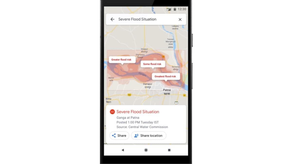
Similar information will be shown to describe the impacted areas of disasters such as earthquakes and flash floods as well. Google has also described how the information can be used in countries like India, which are often prone to river floods due to strong rainfall in the monsoon season. Maps will be rolling out this feature in India with relevant information on flood forecasts and expected severity in flood-prone regions.
Navigation will also be improved for crises later in the year, where Google Maps will provide alerts when routes may be affected due to a disaster. Navigation will also try to route you away from a disaster affected area, rather than following the standard navigation methods of choosing the fastest or most efficient route.
Flood visualisations are expected to roll out in Patna, Bihar to start with, followed by the Ganga and Brahmaputra River regions. These new features will initially be available on Android, desktop, and mobile browser versions of Google Maps.
Existing features for disaster information on Google Maps include summaries, news, Twitter updates from local authorities, emergency phone numbers and websites, location sharing, road closures, and more. Google Maps also recently started rolling out an on-screen speedometer for navigation, in an effort to improve road safety for its users.
Get your daily dose of tech news, reviews, and insights, in under 80 characters on Gadgets 360 Turbo. Connect with fellow tech lovers on our Forum. Follow us on X, Facebook, WhatsApp, Threads and Google News for instant updates. Catch all the action on our YouTube channel.
Related Stories
- Samsung Galaxy Unpacked 2026
- iPhone 17 Pro Max
- ChatGPT
- iOS 26
- Laptop Under 50000
- Smartwatch Under 10000
- Apple Vision Pro
- Oneplus 12
- OnePlus Nord CE 3 Lite 5G
- iPhone 13
- Xiaomi 14 Pro
- Oppo Find N3
- Tecno Spark Go (2023)
- Realme V30
- Best Phones Under 25000
- Samsung Galaxy S24 Series
- Cryptocurrency
- iQoo 12
- Samsung Galaxy S24 Ultra
- Giottus
- Samsung Galaxy Z Flip 5
- Apple 'Scary Fast'
- Housefull 5
- GoPro Hero 12 Black Review
- Invincible Season 2
- JioGlass
- HD Ready TV
- Latest Mobile Phones
- Compare Phones
- Tecno Pova Curve 2 5G
- Lava Yuva Star 3
- Honor X6d
- OPPO K14x 5G
- Samsung Galaxy F70e 5G
- iQOO 15 Ultra
- OPPO A6v 5G
- OPPO A6i+ 5G
- Asus Vivobook 16 (M1605NAQ)
- Asus Vivobook 15 (2026)
- Brave Ark 2-in-1
- Black Shark Gaming Tablet
- boAt Chrome Iris
- HMD Watch P1
- Haier H5E Series
- Acerpure Nitro Z Series 100-inch QLED TV
- Asus ROG Ally
- Nintendo Switch Lite
- Haier 1.6 Ton 5 Star Inverter Split AC (HSU19G-MZAID5BN-INV)
- Haier 1.6 Ton 5 Star Inverter Split AC (HSU19G-MZAIM5BN-INV)


![[Partner Content] OPPO Reno15 Series: AI Portrait Camera, Popout and First Compact Reno](https://www.gadgets360.com/static/mobile/images/spacer.png)


