Google Maps Now Shows Real-Time Transit Information in Select Regions

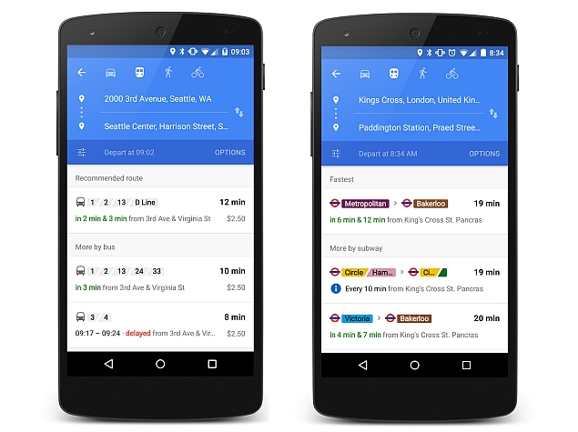
While Google Maps already showed us the scheduled metros, bus routes along with the time of arrival for each bus and other public transit information since 2007, it has now been given the ability to deliver real-time public transit information in select cities and countries on Android.
From Tuesday, users will see a slightly revamped interface that will let users know at a glance at how long they will have to wait, and alternative options. The new Google Maps' real-time transit info however is initially being rolled out to six regions, and will give live arrival timings of buses, trains, and subway systems. The feature will help users know when the next bus or metro would arrive in case they missed the previous one, and, also sends alerts for cancelled routes.
Google has brought on board over 25 new partners in the UK, the Netherlands, Budapest, Chicago, San Francisco, and Seattle for the initial rollout of real-time transit info, in addition to the over 100 partners it already has worldwide. Google has not yet detailed when it would roll out the real-time transit information to other regions in the world, or for the iOS app.
The search giant says it offers public transit information in 18,000 cities and towns in 64 countries across six continents. In addition, the transit feature by Google is being powered by the help of over 6,000 transit authorities, which cover 2.5 million train stations, bus stops and ferry terminals across the globe.
The Mountain View firm at Google I/O 2015 recently said it would soon be bringing offline search to its Google Maps app. The app will also feature complete voice-based turn-by-turn navigation while in offline mode. Both features will be made available sometime later this year. The new offline features announced for Google Maps are aimed mainly for "emerging markets" where mobile Internet coverage is spotty, and data charges expensive, as navigation via GPS is independent of mobile networks.
For the latest tech news and reviews, follow Gadgets 360 on X, Facebook, WhatsApp, Threads and Google News. For the latest videos on gadgets and tech, subscribe to our YouTube channel. If you want to know everything about top influencers, follow our in-house Who'sThat360 on Instagram and YouTube.
Related Stories
- Samsung Galaxy Unpacked 2025
- ChatGPT
- Redmi Note 14 Pro+
- iPhone 16
- Apple Vision Pro
- Oneplus 12
- OnePlus Nord CE 3 Lite 5G
- iPhone 13
- Xiaomi 14 Pro
- Oppo Find N3
- Tecno Spark Go (2023)
- Realme V30
- Best Phones Under 25000
- Samsung Galaxy S24 Series
- Cryptocurrency
- iQoo 12
- Samsung Galaxy S24 Ultra
- Giottus
- Samsung Galaxy Z Flip 5
- Apple 'Scary Fast'
- Housefull 5
- GoPro Hero 12 Black Review
- Invincible Season 2
- JioGlass
- HD Ready TV
- Laptop Under 50000
- Smartwatch Under 10000
- Latest Mobile Phones
- Compare Phones
- Samsung Galaxy F56 5G
- Realme C75 5G
- Lava Yuva Star 2
- Vivo Y19 5G
- iQOO Z10 Turbo Pro
- iQOO Z10 Turbo
- CMF by Nothing Phone 2 Pro
- Motorola Edge 60
- Microsoft Surface Pro 12-inch
- Microsoft Surface Laptop 13-inch
- Honor Pad GT
- Vivo Pad SE
- Moto Watch Fit
- Honor Band 10
- Xiaomi QLED TV FX Pro (55-inch)
- Xiaomi QLED TV FX Pro
- Asus ROG Ally
- Nintendo Switch Lite
- Toshiba 1.8 Ton 5 Star Inverter Split AC (RAS-24TKCV5G-INZ / RAS-24TACV5G-INZ)
- Toshiba 1.5 Ton 5 Star Inverter Split AC (RAS-18PKCV2G-IN / RAS-18PACV2G-IN)


